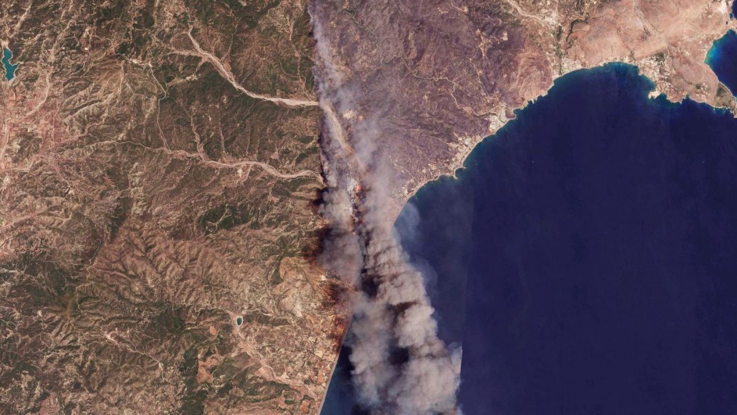
Thousands of tourists have had to escape to safety as huge wildfires continue to rage on the Greek islands of Rhodes and Corfu.
The Greek government said it has evacuated 19,000 people in the “largest ever” wildfire evacuation in the country’s history while commercial airlines such as EasyJet are organising repatriation flights for its customers.
But as the effects of climate warming continue to confront us, what areas are more likely to experience wildfires in the future and how is that recorded?
Adults ‘fight’ to be evacuated – wildfire latest
What is the Fire Weather Index?
The Fire Weather Index (FWI) uses weather data to predict what areas of the world are more susceptible to wildfires.
It indicates fire intensity by combining the rate of fire spread with the amount of fuel being consumed.
The index also considers temperature, relative humidity, wind speed, precipitation, drought conditions, fuel availability, vegetation characteristics and topography.
The higher the FWI, the more likely the weather conditions are to trigger a wildfire.
Please use Chrome browser for a more accessible video player
0:19
Airport closes in Sicily as wildfire approaches
There are six levels of danger in the FWI: very low danger is less than 5.2, low danger is between 5.2 and 11.2.
Moderate danger is between 11.2 and 21.3, high danger is between 21.3 and 38.0.
Very high danger is between 38 and 50 and extreme danger is counted at greater than 50.
The index can be used to shape long-term tourism strategy.
How does it work?
The model allows you to experiment with different factors which indicate how likely a region is to experience wildfires.
Use the Fire Index here.
You apply four different time periods for climate – the current climate which is informed by data from 1981 to 2005, the near future from 2021 to 2040, mid-century from 2041 to 2060 and end of century from 2079 to 2098.
The latter time periods are informed by suspected changes in the world’s temperature.
Which areas are more likely to experience wildfires now and in the future?
Turkey, Greece, Spain and Italy are the most likely areas to experience wildfires at the moment.
Several areas of Turkey, including Izmir, are at extreme risk of wildfires while the rest of the country is at high to very high risk.
As we are seeing at the moment, Greece – and in particular the Greek islands – are at a very high risk of wildfires.
Rhodes currently has a FWI of 47 – the upper end of the very high range.
Read more:
Evacuee ‘lost everything’
British family spent night on floor
Sicily, Sardinia, southern Italy and southern Spain all have high FWI, with the Cadiz region recording a very high score of 38.
Using the current data, the UK has a very low FWI.
Moving into predicting FWI in future years as climate change worsens, the model has an option to apply ambitious, unambitious or moderately ambitious mitigation policies to the results.
Using the unambitious mitigation policy option, southern Europe continues to see a very high to extreme risk of fires.

Flames burn a forest in Vati village on Rhodes Pic: AP
But colder areas such as the UK and Germany are also recording a low danger of fires as the climate warms.
By the end of the century, Germany, Poland, the Netherlands and most of England will see an increased risk of fires.
Who runs the Fire Index in Europe?
The Fire Weather Index is run by Copernicus, which is part of the European Union’s space programme.
Copernicus’s role is observing the Earth and particularly focuses on the planet’s environment. It was established in 2021.
Copernicus uses data from satellites in space, but also data gathered from measurement systems on Earth, working with EU agencies such as the European Organisation for the Exploitation of Meteorological Satellites and the European Centre for Medium-Range Weather Forecasts.
The organisation is named after the Polish Renaissance scientist Nicolaus Copernicus, who formulated a model of the universe that placed the Sun rather than the Earth at its centre.


